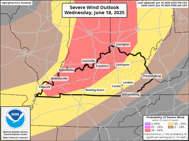
WINTER WEATHER ADVISORY NOW IN EFFECT FROM 9 PM EST /8 PM CST/ THIS EVENING TO 10 AM EST /9 AM CST/ TUESDAY..
Tuesday, December 2, 2025
Accumulating snow continues Tuesday Morning ❄️
WINTER WEATHER ADVISORY NOW IN EFFECT FROM 9 PM EST /8 PM CST/ THIS EVENING TO 10 AM EST /9 AM CST/ TUESDAY..
Sunday, November 30, 2025
Snow & Ice Accumulations Monday Night - Tuesday
Tuesday, November 18, 2025
Strong to Severe Thunderstorms & Heavy Rain
There is a Marginal Risk for strong to severe thunderstorms today. Isolated severe storms capable of producing small hail, damaging winds, and isolated brief spin up tornadoes are also possible. Flooding may become an issue due to repeating rounds of showers and thunderstorms throughout the Tuesday and the rest of the week.
Flash Flood Threat
Radar
Sunday, November 9, 2025
Minor Accumulating Snow
Minor accumulating snowfall is expected tonight through Monday night. A Special Weather Statement for snow has been issued.
..Periods of Snow Showers at Times This Afternoor through Monday Evening...
Colder air will move into the region today behina a strona cold front. Scattered rain showers will be seen across the area during the daytime hours and as the atmosphere arows colder, these rair showers will change over to snow showers late this afternoon and this evening. Periods of liaht snow showers and flurries are expected tonight with just a dusting of accumulation possible.
A stronger weather disturbance will move into the region during the day on Monday bringing widespread snow showers and snow squalls to the region. Temperatures on Monday will remain just above freezing. Minor snow accumulations will pe possible during the daytime hours, especially in heavier snow showers and snow squalls. In general, up to an inch of snow accumulation will be possible in areas east of 1-65. Some travel impacts will be possible on Monday, especially on bridges and overpasses.
Radar
Friday, September 5, 2025
Isolated Strong to Severe Storms Tonight
There is a Slight Risk for strong to severe thunderstorms late tonight. The greatest chance is east of I-65. Beneficial rain, strong winds and perhaps some small hail are possible with these storms.
Labor Day Weekend
Monday, July 7, 2025
Saturday, July 5, 2025
Wednesday, June 18, 2025
Severe Weather Tonight
Storms that moved through about an hour ago developing a shelf cloud in Nelson County, KY.
strong to severe thunderstorms are moving through the area this evening. Flash flooding, damaging, winds, and hail are the primary threats, but a low end chance for a tornado is also possible.
Severe Thunderstorm Watch
Tornado Watch
Radar
Tuesday, May 20, 2025
Rounds of Strong to Severe Thunderstorms
Friday, May 16, 2025
Severe Weather Outbreak Today
The first round of strong to severe thunderstorms are on going across the state. The Moderate Risk is still in effect for additional rounds of storms expected to fire later this afternoon and move through during the late afternoon and evening hours. Tornadoes, some strong, strong damaging winds, flooding, and large to very large hail are all threats with these storms. A Severe Thunderstorm Watch remains in effect until 10 am est.
Tornado Watch
Radar


