Donate to WeatherGraphy™

Thursday, March 12, 2020

Enhanced Risk for Severe Weather & Tornado Watch


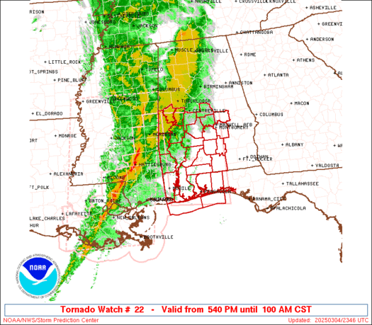
Tornado Watch in effect

"The NWS Storm Prediction Center has issued a

   * Tornado Watch for portions of 
     Central Kentucky
     Northern Tennessee

   * Effective this Thursday afternoon from 505 PM until Midnight
     CDT.

   * Primary threats include...
     A few tornadoes and a couple intense tornadoes possible
     Scattered damaging wind gusts to 70 mph likely
     Scattered large hail and isolated very large hail events to 2.5
       inches in diameter possible

   SUMMARY...Severe storms including several supercells will continue
   to move east-southeastward this evening, particularly in vicinity of
   a warm front. This includes the potential for a couple of tornadoes
   aside from large hail and damaging winds.

   The tornado watch area is approximately along and 55 statute miles
   north and south of a line from 35 miles west northwest of Bowling
   Green KY to 115 miles east of Bowling Green KY. For a complete
   depiction of the watch see the associated watch outline update
   (WOUS64 KWNS WOU8)."


"Tornado Watch for portions of 
     Southern Illinois
     Southern Indiana
     Western and Central Kentucky
     Southeast Missouri
     Northwest and North Central Tennessee

   * Effective this Thursday morning and afternoon from 1145 AM
     until 500 PM CDT.

   * Primary threats include...
     A few tornadoes likely with a couple intense tornadoes possible
     Scattered damaging wind gusts to 70 mph likely
     Scattered large hail and isolated very large hail events to 2
       inches in diameter possible

   SUMMARY...Multiple clusters of thunderstorms will track across the
   watch area this afternoon, with a few supercell storms expected to
   develop.  Strengthening winds aloft will pose a risk of a tornadoes,
   possibly strong.  Hail and damaging winds are also possible with the
   strongest storms.

   The tornado watch area is approximately along and 75 statute miles
   north and south of a line from 25 miles west southwest of Cape
   Girardeau MO to 35 miles northeast of Bowling Green KY. For a
   complete depiction of the watch see the associated watch outline
   update (WOUS64 KWNS WOU6)."


The National Weather Service Storm Prediction Center has upgraded Western & Central Kentucky to a Enhanced Risk with an upgraded tornado threat.

SE Missouri, SE Illinois, SE Indiana, NE, Central Arkansas, NW Tennessee, West, Central, and Eastern Kentucky.


Here is the tornado threat, hatched Significant 10 percent in yellow. 5 percent in brown, and 2 percent in green.


Here is the damaging wind Threat. 30 percent red, 15 percent yellow, 5 percent brown.


Hail threat, 30 percent red, 15 percent yellow, 5 percent brown.


The National Weather Service in Louisville has issued a

* Flash Flood Watch for portions of south central Indiana and north central and east central Kentucky.

* From 5 PM EDT /4 PM CDT/ this afternoon through late tonight

* Multiple rounds of thunderstorms this afternoon through evening will produce heavy rain resulting in potential flash flooding.

A Flash Flood Watch means that conditions may develop that lead to flash flooding. Flash flooding is a very dangerous situation.

You should monitor later forecasts and be prepared to take action should Flash Flood Warnings be issued.


Stay tunned!
Now would be a good time to practice your severe weather satey plans.

Midland WR120 NOAA Weather Alert Radio - White

This NOAA weather radio is highly recommended to get the most recent warnings issued by your local National Weather Service. 

Wednesday, March 11, 2020

Severe Weather Threat Tomorrow (Thursday)

The National Weather Service Storm Prediction Center has placed portions of Western, Central, and Eastern portions of Kentucky in a Slight Risk Furthermore, potions of Tennesee who have been impacted by violent tornadoes earlier this month.

Other states include SE Missouri, SE Illinois, SE Indiana, NE Arkansas, N Mississippi.

5 percent tornado risk in Brown, and 2 percent in Green. Reminder, this is a non zero tornado threat. Just because it is a low threat, it does not mean you will not see a tornado. The strongest storms will be capable of producing tornadoes.


Damaging Wind Threat is 15 percent in yellow, and 5 percent in Brown.

The Hail threat is 15 percent in yellow, and 5 percent in Brown.


Stay tunned!
Now would be a good time to practice your severe weather satey plans.

Midland WR120 NOAA Weather Alert Radio - White

This NOAA weather radio is highly recommended to get the most recent warnings issued by your local National Weather Service. 

Monday, March 2, 2020

5:36 PM Update

Tornado Watch #35

The NWS Storm Prediction Center has issued a

* Tornado Watch for portions of
Northern Arkansas Southern Illinois Southwestern Indiana Western Kentucky Southeastern Missouri Northwestern Tennessee

* Effective this Monday afternoon and Tuesday morning from 520 PM until 100 AM CST. * Primary threats include... A couple tornadoes possible Scattered large hail and isolated very large hail events to 2.5 inches in diameter likely Isolated damaging wind gusts to 70 mph possible

The Storm Prediction Center has placed portions of south eastern and central Kentucky in a Marginal Risk.

The best chance for a more wide spread thunderstorm threat will be in portions of Western Kentucky, Southeast Missouri, East Arkansas, West Central Tennessee, North Mississippi.

Tornado Threat, 5% in brown, and 2% in green (bigger circle)                                                       

Wind Threat, 15% in yellow, 5% brown.

Hail threat, hatched significant circled in the black circle.
Pivotalweather.com

HRRR Model


The chance for thunderstorms begins at 3 pm through 8 am tomorrow.
A few of these storms may be severe, but will mostly be sub severe. 
I will keep you updated through the day.

Remembering March 2nd, 2012

Tornado Outbreak

This is a collage by me, but these pictures were not taken by me and belong to their rightful owners: storm chasers, Meteorologists, and bystanders.

I know this is an old outdated video, but I made this when I was 14 years old. This was the first tornado outbreak of my career once I became interested in weather. I was very nervous seeing how serious Meteorologists and Storm Chasers was talking about the forecast and looking back, seeing all the ingredients come together makes it that much more scary.


Wednesday, February 26, 2020

Light Snow Possible Tonight, Heavy Rain Sun-Wed.


Snow showers are expected to develop late this afternoon and evening where up to an half an inch will be possible, mainly in Southeastern Kentucky.

PivotalWeather.com

The National Weather Service has issued a Special Weather Statement


Scattered snow showers can be expected this evening. Some of the heavier showers will produce briefly gusty winds and will create slick spots on roads with minor accumulation...especially on elevated surfaces and untreated pavement.

The snow showers will taper off by, or shortly after, midnight. However temperatures will tumble well into the 20s so any snow that does accumulate will persist on the ground through the night.


Next we will turn out attention to heavy rainfall potential later this week. Here is the NWS Louisvilles current thinking on rainfall.


Wednesday, February 12, 2020

Flood Threat & Severe Weather Wednesday

For Central Kentucky Issued Today:

11:00 pm update. 02/12/2020.


The National Weather Service in Louisville KY has issued a

* Flood Warning for
  the Rolling Fork River near Boston.
* from this evening to late Saturday night.
* At  9:30 AM Wednesday the stage was 33.7 feet.
* Flood stage is 35.0 feet.
* Minor flooding is forecast.
* Forecast...Rise above flood stage by this evening and continue to
  rise to near 38.9 feet by early Friday morning. The river will fall
  below flood stage by Saturday before midnight.
* Impact...At 40.0 feet...Water begins to cross low spots on some
  county roads. Some homes in flood plain are cutoff.
* Flood History...This crest compares to a previous crest of 38.8
  feet on Mar 16 2015.


* Rainfall of 1 to 2 inches with locally higher amounts possible.

* Rain will move in Wednesday afternoon with heavier intense rain bands moving in Wednesday evening, increasing the risk for flash flooding.

A Flash Flood Watch means that conditions may develop that lead to flash flooding. Flash flooding is a very dangerous situation. All of the rain will runoff leading to an increased threat of rising rivers...some which will go into flood.

You should monitor later forecasts and be prepared to take action should Flash Flood Warnings be issued.
Flash Flood Watch

MODERATE TO HEAVY RAINFALL EXPECTED LATE WEDNESDAY EVENING AND NIGHT...

.Total rainfall amounts of 1 to 2 inches with locally heavier amounts on top of a very saturated ground will lead to an increasing threat of flash flooding into Wednesday night.

The National Weather Service in Louisville has issued a

* Flash Flood Watch for portions of Indiana and Kentucky, including the following areas, in Indiana, Clark, Crawford, Dubois, Floyd, Harrison, Jefferson, Orange, Perry, Scott, and Washington. In Kentucky, Adair, Allen, Anderson, Barren, Bourbon, Boyle, Breckinridge, Bullitt, Butler, Casey, Clark, Clinton, Cumberland, Edmonson, Fayette, Franklin, Garrard, Grayson, Green, Hancock, Hardin, Harrison, Hart, Henry, Jefferson, Jessamine, Larue, Lincoln, Logan, Madison, Marion, Meade, Mercer, Metcalfe, Monroe, Nelson, Nicholas, Ohio, Oldham, Russell, Scott, Shelby, Simpson, Spencer, Taylor, Trimble, Warren, Washington, and Woodford.

* From Wednesday mid afternoon through Thursday morning

* Rainfall of 1 to 2 inches with locally higher amounts possible.

* Rain will move in Wednesday afternoon with heavier intense rain bands moving in Wednesday evening, increasing the risk for flash flooding.

A Flash Flood Watch means that conditions may develop that lead to flash flooding. Flash flooding is a very dangerous situation. All of the rain will runoff leading to an increased threat of rising rivers...some which will go into flood.

You should monitor later forecasts and be prepared to take action should Flash Flood Warnings be issued.


(SWS Expired)Special Weather Statement for Wintry Mix  Tonight.

Low pressure moving from east Texas to northeast Kentucky Wednesday into Wednesday night will bring widespread precipitation to the region.

In the early morning hours a rain/snow mix will be possible in southern Indiana and north central Kentucky. The precipitation should be light and ground temperatures above freezing, so little if any impact is expected. Any mix that does fall will transition to all rain by mid morning.

Light to moderate rain will then continue into the afternoon. As the low approaches Wednesday evening, heavy rain is expected. Areal flooding will be a possibility, especially east of Interstate 65 and south of the Ohio River. Smaller creeks and rivers will rise.

A narrow line of robust showers will cross the region during the evening hours. This line will bring a brief period of enhanced rainfall rates and possibly some gusty winds.

The rain will taper off after midnight as the system progresses to the east.

People with interests in flood prone areas should monitor the latest forecast information and be prepared to take action


Excessive Rainfall Outlook


The National Weather Service Storm Prediction Center has placed portions of Eastern Kentucky in a Marginal Risk for gusty showers. Slight Risk for severe weather on Wednesday. Damaging wind, hail, and a few tornadoes possible. In Louisiana, Mississippi, Alabama, Tennessee.


There will be some wiggle room with this outlook and I'll share the NWS SPC images as they update it. Some locations may be added or dropped as we get closer to Wednesday.

Stay tunned!
Now would be a good time to practice your severe weather satey plans.

Midland WR120 NOAA Weather Alert Radio - White

This NOAA weather radio is highly recommended to get the most recent warnings issued by your local National Weather Service. 

Thursday, February 6, 2020

❄ Light Snowfall Tonight ❄

3:55 pm update for round 2.

Special Weather Statement

Snow is expected to develop after midnight ahead of a quick moving system and eventually push east of the region by late morning. A dusting to a half inch of snow will be possible by tomorrow morning. A few slick spots will be possible in areas that see light snow accumulations. Any snow that accumulates should melt by late morning as temperatures rise well above freezing.


TropicalTidbits.com

The Nam-3km model shows a band of snow showers pushing through around 6 am to 12 pm.


_________________________________________________________________

2:15 pm Final Update for round 1..

Snowfall started around 11 pm edt February 6th, and continued to around 12 pm edt February 7th. For my location we ended up with a total around 1.5 inch while locations to my east received more than 2 inches.

This is a picture that I posted on my Instagram story, IG stormtracker_4.


I know it wasn't a lot, but we've got to be happy with what we do get as the winter season clock winds down.
_________________________________________________________________


Snow lovers rejoice, beggars can't be choosers. We are looking at the potential for 1 to 2 inches of snow tonight.


The National Weather Service has issued a Winter Weather Advisory.


WINTER WEATHER ADVISORY IN EFFECT FROM 10 PM EST /9 PM CST/
THIS EVENING TO 1 PM EST /NOON CST/ FRIDAY...

* WHAT...Snow expected. Total snow accumulations of one to two
inches. Locally higher amounts possible, mainly in the Bluegrass
Region.

* WHERE...Portions of south central Indiana and central Kentucky.

* WHEN...From 10 PM EST /9 PM CST/ this evening to 1 PM EST
/noon CST/ Friday.

* IMPACTS...Plan on slippery road conditions. The hazardous
conditions could impact the morning commute.

PRECAUTIONARY/PREPAREDNESS ACTIONS...

Slow down and use caution while traveling.

The latest road conditions for the state you are calling from can
be obtained by calling 5 1 1.


74% Chance of receiving at least 1" of snow.

45% chance of at least receiving 2" or more of snow.

Radar from Accuweather


Saturday, February 1, 2020

Dixie Alley Severe Weather Threat Today.

The National Weather Service is monitoring the potential for a 2 day severe weather event.

WW0022 Radar
For today, the NWS SPC has issued an enhanced risk for severe weather for locations in orange, a slight risk for locations in yellow, and a marginal risk in dark green.


Tornado threat
10% hatched significant for tornadoes across portions of Mississippi and Alabama.


15 percent wind threat highlighted in yellow.


The hail threat remains low with a 5 percent chance.


tomorrows outlook


tornado threat
wind threat
hail threat


I will continue to monitor the National Weather Service and Forecast Models for changes.

Midland WR120 NOAA Weather Alert Radio - White

This NOAA weather radio is highly recommended to get the most recent warnings issued by your local National Weather Service.